
Magenta Lizard
-
Posts
4,284 -
Joined
-
Last visited
-
Days Won
76
Content Type
Profiles
Forums
Calendar
Everything posted by Magenta Lizard
-
I explained this when people were complaining about it earlier, that my calcs came up with a different value from someone else’s. We are working from blueprints for the concrete footings that support the coaster. We don’t have blueprints for anything that goes above them (other than attachment brackets). Us nerds, as you put it, understand the ambiguities that exist when all we know for sure is the footing locations. We have no idea, for example, how tall the coaster will be off the ground before it begins the lift (think of the different heights between Banshee, Diamondback, and Racer at the base of the lift, for examples). We understand we can make certain calculations making certain assumptions, but it is pretty much impossible to say absolutely for sure from the data we have exactly how tall it will be. Each nerd says what assumptions and data they personally used and we are willing to accept the equally reasonable results even if it doesn’t match perfectly with the results we got with our own different assumptions. Because there are things we just don’t and can’t yet know. Educated guesses are the best we can offer. Things are pointing to a giga from nearly everyone’s calculations and estimates, though. Just be satisfied with that if you don’t understand all the other details
-
I suppose if you want to get technical but I’m not so sure how many of the creatives working for Cedar Fair in 1990 (or Paramount parks in 1996 for that matter) are still a part of the company today to give much help. They have access to whatever archives and resources exist at both parks if they want them since Cedar Fair owns the former Paramount parks now. In recent years they have outsourced theming anyway, such as Daniels Wood Land and Holovis for Mystic Timbers. So it may be a moot point regardless.
-
You’re going to slap your head but... Flight of Fear Not that it wasn’t a long time ago too but somewhat less of a long time.
-
I’m kind of confused what you’re doing with that. Are you saying that Fury’s lift hill is only 32 degrees because of the flattened shadow it casts on the photo used on google earth? Or is there something I’m missing about your calcs? Because Fury’s lift is clearly not that shallow If that isn’t where you were going with this, I don’t understand where you are?

-
I’d personally much prefer the stadium seating. I refuse to believe the troll layout because there don’t seem to be tunnels. I need tunnels
-
So, this post has a good copy of the page with all the footings labeled if you click on the image and scroll in: and this is a clear posting of all the coordinate data for those footings:
-
Yes there were. I think it was about three pages after the initial ones, maybe. It got lost in the shuffle with the troll posting the layout, but someone did post clearer shots after they were asked. They’re the ones I used to make my calcs. I will try to find them again and do direct links... not on this post tho because it will probably be buried by the time I find them smh
-

Coasterstock 2019 - May 17th & 18th
Magenta Lizard replied to IndyGuy4KI's topic in Kings Island Central Newsroom
You mean Project X -
Yeah, I guess that’s right. I realized it after I asked. There could potentially be in-line rolls but at the speeds of a giga I think those probably wouldn’t be very fun
-
In a top-down view, how can you really tell? (That there are no loops)
-
Makes a big difference
-
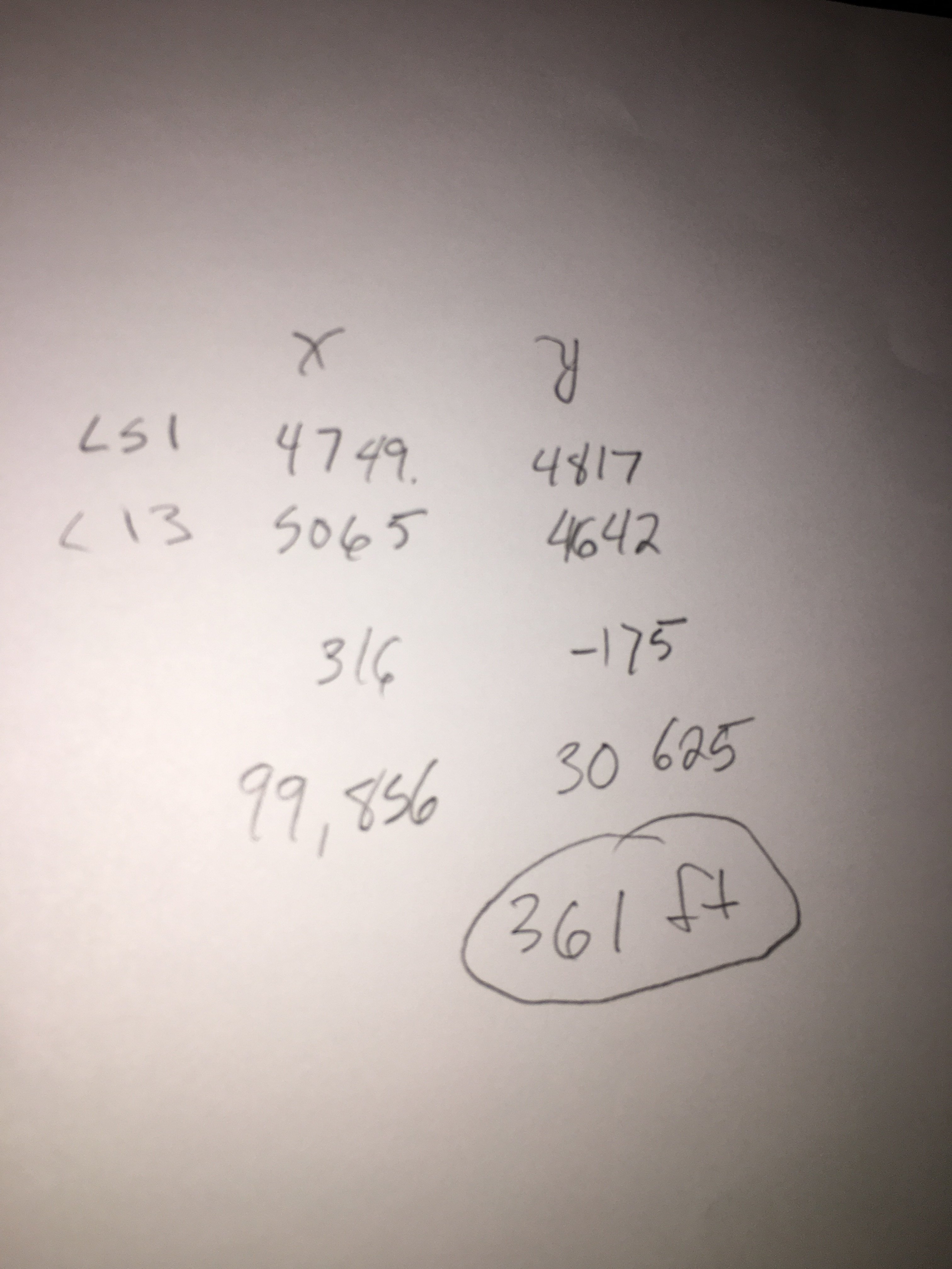
The difference was that the length he measured went past the line of the L8R footing that I was using as the end of the lift hill. I do not know for certain at which point in the footings the lift will end, but I can be relatively sure by its prefix (L) that is still part of the lift. So my 300 ft calc is a minimum. It may be taller (I could be wrong about where it stops, or the angle may be steeper, and there will almost definitely be an additional height from how far it is off the ground at LS1). But it almost certainly won’t be shorter.
-
Here’s my data and math: the first values are the (rounded) x and y coordinates of LS1, a footing at the beginning of the lift, and L8R a footing at the end of the lift. The third line is the difference between those values, which gives the distance in the x and y axes. So, using the Pythagorean theorem a squared plus b squared equals c squared, I was able to find the distance of 307 feet. L8R is to the right of the centerline of the coaster track so it means the actual distance along the ground along the path of the coaster is slightly shorter (I didn’t calculate it from there, just estimated around 300). If the lift is 45 degrees, the height at the top would be the same as the distance traveled on the ground. Except it probably won’t start at ground level. So whatever height it is at the base of the lift, plus ~300 feet. There you go, figured out mathematically from the blueprint data. Not from an erroneous scale.
-
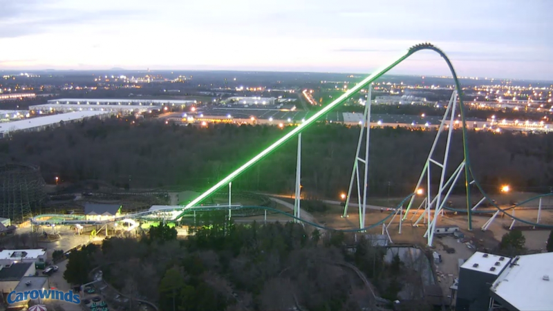
I’m personally saying I did the math of the distance between the presumed beginning footing and ending footing using the exact coordinates given on one of the pages of the blueprint. It is around 300 feet tall plus whatever the height is coming out of the station, assuming a 45 degree lift. If the angle is sharper or I am incorrect about where in the footings the lift ends, it could be taller. But it is almost definitely not shorter, not the 200-some feet that scale on the first page says. The scale is wrong. This is a giga
-
Ok, so I got excited and I ran the coordinates from LS1 and L8R, as given in the filed blueprints. They’re ~307 feet apart. That gives an approximate length (along the ground) of the lift hill to be around 300 feet. It won’t be starting at the ground, so if the lift is 45 degrees, it /will/ be a giga, but not a record breaking one: just a little over 300 feet.
-
I actually have a bachelor of mechanical engineering. I’m out of practice, but what is being said about using the scale on the drawing to find the length of the lift hill is correct, that scale suggests only a little over 200 feet for the length of the lift hill. However, as is also being said, if the scale is correct makes the size of the station ridiculously small. In addition, it seems to make the distance they’ve already cleared to be twice as long as it needs to be. So, it is entirely possible the scale itself is wrong. I personally would much rather believe the coordinates given to each individual footing. If nobody else does, I will sit down with it later and do the math to find the distances.
-
Those who know about these things: is there something specific about these drawings that make you believe they show the entire lift hill? I didn’t think when I saw it that it was the whole lift, but I’m wondering if there is a clue I’m missing
-
The distances between whatever acts as the zero point, and the coordinates for the footers is around a mile. So, if that stake is zero point, the coaster isn’t going to be anywhere nearby I do think it would be an interesting project to puzzle out what the zero point is from the coordinates given in the Mystic Timbers/Project 2017 drawings, now that we know where it actually went. But it would be quite the project and I don’t know if it is what they use for all projects anyway. The most definitive data will be when footings start going in. That will probably give us a much more understandable idea of the orientation than trying to puzzle out these coordinates.
-
Because Kings Island was annexed by Mason, they file with the city rather than the county now. If you do a records search through the Warren County site you’ll see that none of the recent projects have any listings there. It just happens that some troll was able to write a URL that made the county site say pretty much anything they wanted it to.
-
I believe the Mason Municipal Center, and the Engineering, Building, and Planning Dept. Ask for either the Kings Island construction blueprints and/or Project X blueprints. As I said, the ones I saw were filed April 18, and there may be more recent ones.
-
Well if you insist. Recognize this is from memory and my memory isn’t the best, nor are my sketching skills. The red rectangle represents a bunch of closely set footings that appeared to be delineating the station. The purple lines represent rows of somewhat farther spaced individual footings, and I do recall they seemed to make a hard left turn toward the station. The blue lines represent widely spaced larger footings that I’m assuming are the beginning of the lift hill.
-
It’s also why Mason police are often on site in addition to the KI police and security forces
-
To be fair, it’s pretty easy to avoid this thread if you’d prefer to be surprised. Other places on the web, maybe not, but it’s pretty clear here. What is being done and discussed here is exactly what this thread is made for.
-
There are probably people who can determine type of coaster from the placement of a few footings and technical drawings of the attachment points. I am not one of them. I’m still team Giga, myself, tho.
-
I don’t think it would be very interesting if I did. It’s just the footings for what appears to be the station, return, and beginning of the lift hill. The locations given for the footings were from an undisclosed zero point around 5000 feet away, and there wasn’t anything indicating north on the drawing. Someone will go down and buy copies and share them soon I would think.