

fryoj
-
Posts
1,456 -
Joined
-
Days Won
9
Content Type
Profiles
Forums
Calendar
Everything posted by fryoj
-
Using Fury's descent angle and peak radius, Project X is 285 ft tall when measured from the backbone footer height. That footer is 10 ft lower than the footers at the peak. That would mean true height would be 275 ft. Thats using the footer coordinates and lift angle from the blueprints. I have trouble believing that myself, but the math has been done by more than one person. I think they can get some with a tighter radius and a steeper drop, but 25 ft is a lot with the margins laid out in the blueprints. I'd be happy to see someone do some math and prove that wrong. But "theres no way they'd do that" isn't exactly proof.
-
Thats a tough one. We do not know the radius of the top of the lift, so we are just making educated guesses based on the info included in the lift blueprints. Using Fury's and Leviathan's lifts for drop angle and radius, combined with the lift angle and footer locations, and the fact that the ground level is 10 ft higher at the peak than at the base, the math says the lift will not be 300 ft tall. That being said, I can't imagine that they won't call it a giga regardless what the numbers are. Even if it just a 301 ft drop, they'll use that as a selling point. Theres enough uncertainty in the peak geometry that it still is possible that it stands 300 ft. though.
-
Just when you think the page is moving fast, it sputters..
-
The leaker would not need access to CAD files unless they faked them. The leaker tried to post a pdf. The pdf could have been a part of a digital copy of the prints, or something they scanned from a paper copy. They wouldn't need CAD versions to do that.
-
They'd likely only have one working on the coaster proper no matter how big it is. Now it's possible that one is doing the queue and one the coaster. It crosses the ravine. The black dot signifying the low point in that stretch is 3 contour lines up hill from that low point of the ravine. It's already on its way up before it gets to it. Not sure what else you want to see on the track portion, but it shows footers, supports and rail position throughout. It also has black dots and unreadable text(probably heights) at high and low spots. There really isn't more detail to show on a coaster. While the companies sign NDA's, I doubt every employee in the company does. Even if they do, I don't think a $10 an hour secretary right outta high school, or a $12-$15 an hour guy who ties rebar for a concrete company may not quite grasp what that NDA they signed means. Both might have seen the plans their company was contracted to work on. Or hell, take that some company who has a boss who's 15 year old kid loves roller coasters but hates dad, but dad thought he'd impress the kid by showing him what he's working on. That kid may not be able to grasp the trouble he'd get his dad in for posting that. "I'll just make a fake account an no one will know it was me". Theres probably 100+ people who have seen the layout so far and there could easily be as many reasons why they thought it would be fun to leak it. They aren't even acknowledging that they are building anything at this point. They certainly aren't going to go out of their way to address this.
-
OK. Take the posted image and make an equally detailed alternate layout that also matches the clearing and the city blueprints. Since it's that easy. The Blueprints we had for MT were just of the footers for one side of the reservoir crossing. There just happened to be an overall project layout on the page to show area of work. KI probably learned their lesson about having that image on them, but didn't expect someone else to leak it.
-
Yeah, I have said that if it's not the final ride, it was one option pitched to the park from B&M. And I still can't discount that as a possibility. After laying the layout on the pic of the clearing though, I'm fairly certain that's not the case as it just matches up too perfectly. Either way, that layout was not created by someone as a fake.
-
Someone creating a fake to mess with people would have just drew a wireframe path on a map or, these plans if they somehow could have gotten access to them. They would not have drawn a detailed layout that is identical to the station plan, put footers throughout the ride path, drew the rails to show the banking of the track, and done detailed queue and path drawings. They even tied the old Firehawk queue into the FOF building. What purpose would that have in a fake? If you were faking it, you'd have tied the Firehawk queue into the new ride to give it more credibility since we know they left the queue. That is hours and hours of work they did, in CAD. Who would put that kind of time into a fake that could have been debunked in days if they cleared more trees out or started putting the station somewhere else? I get that people are disappointed that this isn't a 400 ft tall, 9000 ft long world breaking coaster, but let's use some logic here. Wishing that the layout is fake doesn't make it fake. It was drawn by someone with access to the CAD plans of the park and the new ride as that is definitely the station in the city plans. It's legit guys.
-
They are extremely detailed because they are CAD drawings. The park would have sent the master copies to B&M for them to add the new ride to. Different colors signify different things on different layers. The new ride matches the detail of everything else on there. You can see the footers, the supports, the bank of the track, queue line, everything. Someone didn't scan a blueprint in and add that. Whoever drew them had the master CAD files. This is not a fanboy or troll creation.
-
Doubtful. If anything, the chosen placement shows they aren't going to expand into that area. At this point, they'd have to move all or most of the maintenance buildings to do a real expansion. Not completely out of the question, but just not likely. They could have re-routed Lil Giga and made a lot more space for expansion there.
-
There are no underground sections.
-
I think that pic actually does more to confirm the leaked layout than anything I've seen yet. In a completely unrelated note, I drew a layout that would fit perfectly in that opening. Any resemblance to any known or unknown leaked layouts is completely coincidental.

-
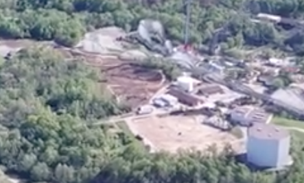
That pic was from opening weekend. They were still clearing. From @sixohdieselrage on May 5th
-
.... The trees are WEST of the DA path. The helix is EAST of the DA path. The guy who made that video was wrong.
-
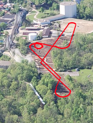
The "ravine" everyone keeps quoting is only a 20 ft drop from the station height. And it is over near where the second hill is, and not at the base of the first drop. The "ravine" is shown in this pic below. It's less a revine and more of a swell.
-
They going to miss it more than the relocated Funnel Cake hut and WWC entrance you referenced? Footers will probably start going in this week since it's supposed to be dry. They will start putting up supports right after the announcement date.
-
Firehawk's removal says Hi.
-
Other than I think he's too tall on that hill before the helix, it's pretty spot on.
-
Fairly positive that the turnaround will be Fury's Treble Clef as well.
-
The layout was not a part of the blueprints. It was leaked separately. But you can clearly see everything in the blueprints on the leaked plan.
-
Well theres no reason to do a lift hill on a launched coaster.
-
It would still be longer than the leaked plans.
-
You can ignore the scale on the overview page. The real numbers are the footer coords and the angle on the backbone footer. Those are what the surveyors and concrete guys are going to use. They aren't going to be sitting there with a yard stick and that page trying to estimate how far to put the next footer at a 1:20 or 1:40 scale. From where the widest lift footer is, to the very deepest part of that ravine is a 30 ft drop according to Google earth. They cannot get the top of the track down to that 30 ft point. You have the thickness of the track, The support, and the footer itself. You are 5 or 6 foot minimum off the ground that way and thats if they go straight from track to footer. You also would never put a footer in the middle of a ravine. Too much erosion potential. They'd put them up on the bank. So we are, at best, 20 foot from the top of the high point of the drop footers now. Next, that ravine is too narrow to actually put track into. It will pass above it. It is also almost to the point where the coaster peaks again and turns towards the turnaround according to the supports shown on the leaked layout. When it gets to that ravine, it'll already be on its way back up. Not to mention the point where the peak of the drop footers are is 10 ft taller than the station height. So it's not even going to be a true 300 tall at that point. This thing is going to need the ravine drop just to get over 300 ft on the drop.