

fryoj
-
Posts
1,456 -
Joined
-
Days Won
9
Content Type
Profiles
Forums
Calendar
Everything posted by fryoj
-
Unfortunately, thats not what the plan measured out to. I got 4600 ft straight line, so whatever you gain from up and down hills is all it's going to be.
-
You are probably thinking of the full layout that was anon leaked on here yesterday.
-
If you were going to legit leak something you weren't supposed to, would you use a username that you've been using for years and people know, or would you create a new name? They were leaking them. They weren't trying to boost their ego with an "I know something you don't know" like has happened in the past. Like another has said, no one got the actual pdf. The Original poster didn't upload them right or something. When he realized it, he took screen caps on his phone and sent that to people. It was two pics that showed everything. The person who ended up posting them here tried to stitch them together, but, probably in a hurry, didn't get them lined up. But the originals line up correctly.
-
Hmm. So it's not going to have a backbone footer on the drop. No way to know the descent angle then. I was hoping there would be another diagram like the angle footer on the lift page, but it's not meant to be. Thank for looking that up.
-
I wasn't referring to you as estimating. I'm talking about the ones laying layouts on google maps. You did the math like myself and others. We just don't have the drop angle to verify where the top of the lift stops. There will still be a small margin of error there as we'll not have the radius, but assumptions can be made. Another thing you'll need to plug into your cad is ground height. It appears that you didn't account for the 10 ft height increase from L3 to L13. I didn't either. It drops 3 ft to L16, so it's even a smaller margin of error. But if you are going to get things to a fraction of an inch, you don't want to leave an error like that in there.
-
And I quoted 5 pages worth of posts, typed them all into one post so I didn't have to double, triple, etc post, and hit the wrong button at the bottom of the page and lost it all. So screw it.... But @Bansheeback or @RuthlessAirtime do you have the page with the 2 / S3.2 footer detail? That should give us the drop angle and allow us to put the lift height to bed.
-
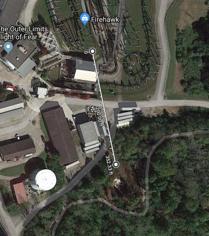
The difference is coming from people trying to overlay a cad drawing onto a google map. Theres different ways to do that and you get different numbers depending on where you measure from. However we have true numbers from the plans. The base of the lift is ~350 ft from the widest/tallest set of supports and the lift is 40 degrees. Math gives you a height around 290-300. The footers at the high point are also 10 ft higher than the base footer. So that knocks some of the overall height relative to the ground. The only question is how far past that widest set of footers does the track keep going up before dropping. It hasn't been brought up, but the leaked plans show the Firehawk queue being tied into FOF. I wouldn't be surprised if it was set up to be used as an overflow queue for the new coaster.
-
It would certainly make anything leaked from this point be questioned. We are using footers to do the calculations. The footers are on the ground. The backbone attaches directly at the footer. How high the station doesn't factor in anywhere. That ravine isn't much of a ravine. See below. And it crosses it on the way back up based on the footers shown in the leaked plans. At that point, to measure actual drop, you do have to account for distance track is off the ground, So they aren't going to wedge the track down in that narrow ravine.
-
Theres no way that decision was made mid summer. I think you are off on your line. Play with transparencies and scaling and overlay the leaked plan over the google map. Get the existing buildings and rides lined up as close as possible before doing anything else. After that you need to overlay the lift footer plan from the city docs to find the location of the backbone footer as its not visible on the leaked plan. Thats the starting point for your line. The ending point it debatable because not knowing exactly where the peak is. I could see pushing it to 370 total length, which gets it to 310 height, but that's speculating. The chance of it being a fake revolves around your thoughts on if the park intentionally released a fake.
-
I used the coords from the document thats been posted to calculate the distance between the bottom of the lift and the tallest support footer. I backed it up by laying the leaked plan over a google map then used the google map measure feature to measure from the base of the lift to the high point. In both cases I'm getting around 350. With the coords I got 357. The measure feature was obviously a lot more inconsistent, but close. This is ballpark where it should be. I'd have to post docs that the mods don't want posted to show my work.

-
All that is in the doc are the footers marked on the plan. The L's are the lift. ST's are the Station. T's are transfer. M's are the shed, so probably called maintenance internally. The C's look to be the turn around or Curve at the station. Thats all thats in the doc unless theres a lot more data not posted.
-
Not sure where you are measuring from or to, but that 435 is off. It gives the coords for all of the footers relevant to the lift. The overall footer diagram gives the names for each footer. The base of the lift is LS3. The triangle and matching footer for the top are the L13's. Using the coords from those, you can calculate their distance apart which is right around 357 ft.
-
This is the relevant image. The 4 digit numbers in the 3rd and 4th column are the coord. 5th is elevation. https://KICentral.com/thumbor/1RnNgkvNIxyBYA4sAfi9rCw2_Is=/fit-in/1280x768/https%3A%2F%2Fuploads.tapatalk-cdn.com%2F20190508%2F17a90c6d19179624a53283b9b774073c.jpg
-
The problem is, that backbone footer that we are measuring off of is on the ground. I went back and used the coords in the plans and it is 357 ft from the backbone footer to the Triangle footer. Still hard to read, but looks like a 40 degree(with 50 on the opposite angle)to me. In that case it's 299.55 for a height at the triangle footer. The other issue is the Backbone footer is at 740 ft. The Triangle footer is at 750 ft. That means relative to the ground, the lift will be ~290 ft at the triangle footer. The question is, where does that footer's supports attach to the track. Is it like Fury and attach at the peak, or like Leviathan and attach off peak. I think this thing will be called a giga, but its going to be with funny math or just barely.
-
@Bansheeback can you see that angle on your copy or get a clearer pic?
-
At 39 degrees I'm getting 285 ft at the triangle footer. Granted I'm measuring using google maps, so ymmv.
-
They'll call it a giga. Carowinds still calls Fury the tallest Giga coaster in the world. I've laid the plans over top Leviathan's lift and it's very similar on footer layout. If anything it's a shorter length. If it's going to be taller, they are going to have to increase the angle. Which, if they do that, they increase speed, which makes the short length even more puzzling. I get hope, but this isn't looking like a record breaker. It's all out there. Keep reading the reddit thread, someone posted the rest of it. Just a bad crop. If it was a highly detailed fake, no one would ever just leave half a loop out there.
-
So how do they market this thing? Tallest and fastest coaster at ki? I'm having doubts that it'll even be taller than MF based on the docs. Even if it is, you are still only adding "in Ohio" to the list.
-
lol, might want to read the other 40 pages since then. or just go to r/rollercoasters on reddit for the cliff's notes and artwork.
-
It's the same amount of seats per train. The DB trains are just longer. Also, with us knowing that the station and transfer track are both single pieces, we pretty much know its not stadium seating.
-
50 seconds from drop to break run. I'd say thats close though. Off a little here and there, but nothing too much other than that tall hill between the turn around and the helix won't be there though. lol
-
For those trying to assume a 45 degree lift and are using the length, Fury's measures out at around 400 ft, and we know it's not 400 ft tall.
-
Not sure whats up with the yellow dots, but they are wrong. The triangle footer and the one across from it are the ones for the top of the drop. The smaller two between them and the backbone footer are the smaller set to support the middle of the drop. Instead of leaning back and being in line with the wide footers they are more vertical. Fury has a building under its drop. Leviathan has a coaster. They probably required the footers be placed differently.
-
They do not go as wide.